Tulsa's growth from a dusty cattle stop on the Frisco Railroad to a sprawling oil capital left a patchwork of fill, alluvium, and weathered shale that can surprise even experienced drillers. The Arkansas River corridor and its tributary creeks deposited layers of sand, clay, and gravel in patterns that standard borings miss. Electrical resistivity and Vertical Electrical Sounding (VES) cut through that uncertainty by mapping how current flows through the subsurface, distinguishing saturated clays from dry sand or intact limestone before a backhoe ever breaks ground. When the City of Tulsa expanded its levee system after the 1986 flood, geophysical profiling proved essential for identifying paleochannels hidden beneath clean-fill caps. Today's developers and geotechnical engineers use the same principle—inject current, measure potential, model stratigraphy—to plan foundations, retention ponds, and stormwater infiltration systems with far fewer blind assumptions.
In Tulsa's river-terrace geology, the resistivity contrast between saturated alluvium and weathered shale can exceed an order of magnitude, making VES one of the fastest ways to map bedrock depth across a site.
Process and scope
Site-specific factors
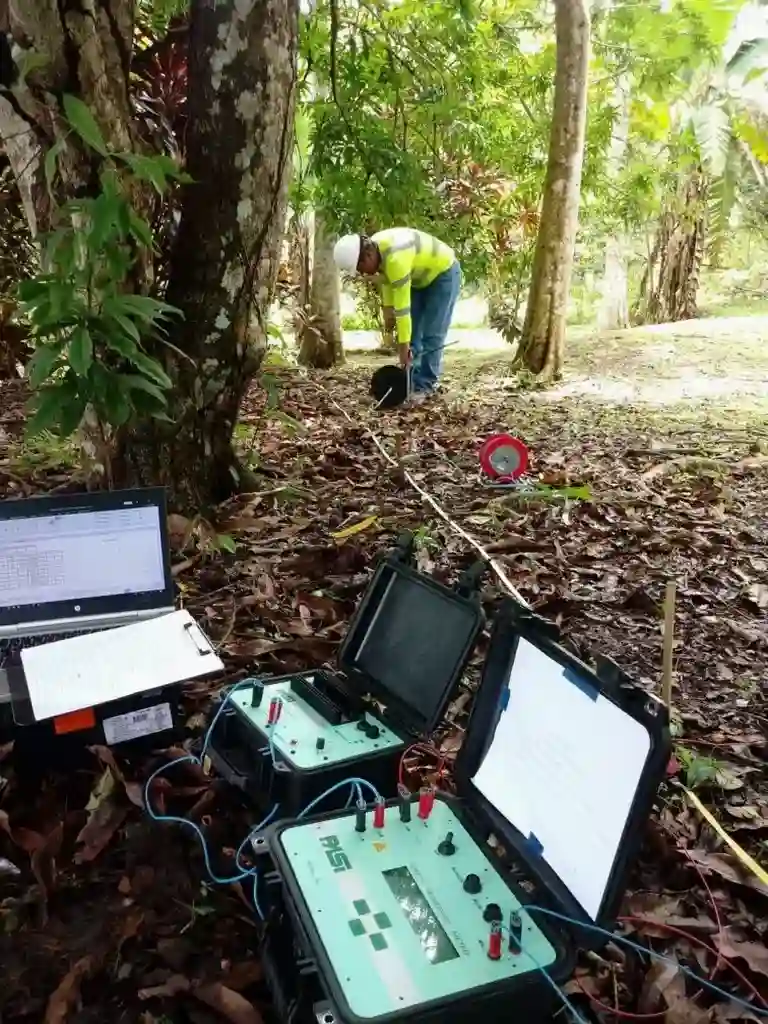
The crew walks the line with a red-and-yellow Syscal Pro unit and a coil of heavy-gauge cable, pounding stainless-steel stakes every five to fifteen feet across a staked transect. In Tulsa's mid-summer, dry surface soils can create contact resistances so high the instrument refuses to inject current, so we carry salt-water saturating cans and bentonite slurry to improve electrode coupling on the fly. The biggest risk isn't the equipment—it's interpreting a low-resistivity anomaly as groundwater when it's actually a clay-filled abandoned channel or a buried metal pipe from a 1920s wellhead. That's why every resistivity line gets ground-truthed against available ODOT boring logs, county well records, or at least one calibration test pit. Skipping that step has led to expensive surprises: a contractor east of downtown once hit an uncharted brine plume that resistivity had flagged but the report didn't contextualize, and the resulting sulfate attack on the concrete footings triggered a six-figure remediation.
Regulatory framework
ASTM D6431-18 — Standard Guide for Using the Direct Current Resistivity Method, ASTM D420-18 — Standard Guide for Site Characterization for Engineering Design, USACE EM 1110-1-1802 — Geophysical Exploration for Engineering Investigations
Related services
Vertical Electrical Sounding (VES) for Bedrock Depth
A single-point Schlumberger sounding that expands electrode spacing stepwise to profile resistivity with depth. Ideal for large-lot residential or commercial pads where the primary goal is confirming depth to the Pennsylvanian limestone or shale before designing spread footings or drilled piers.
2D Electrical Resistivity Tomography
A multi-electrode line towed or staked across the site, producing a continuous cross-section of resistivity. Used for levee investigations, mapping paleochannels, locating karst features in the Boone Formation, and delineating groundwater plumes near former refinery parcels.
Typical parameters
Common questions
What does a VES or resistivity survey cost for a typical Tulsa commercial lot?
For a standard commercial site survey with 8 to 12 VES points or a single 2D line up to 400 feet, the budget typically falls between US$640 and US$1,120. The final figure depends on electrode spacing, terrain access, and whether we need to coordinate utility mark-outs or traffic control along Tulsa right-of-way.
Can resistivity tell the difference between wet clay and groundwater in Tulsa's alluvial soils?
Partially. Both saturated clay and fresh groundwater produce low resistivity, but the geometry of the anomaly and the surrounding lithology provide strong clues. We correlate the resistivity profile with a boring log or a cone penetration test whenever possible—clay will show low tip resistance in CPT data, while a clean sand aquifer will not.
How deep can a VES survey effectively see near the Arkansas River?
With Schlumberger spreads extending to 600 feet of current-electrode separation, we routinely resolve resistivity contrasts down to 200-300 feet. That reaches well below the typical depth of Quaternary terrace gravels and into the underlying shale bedrock across most of Tulsa County.
Do buried utilities interfere with the resistivity readings?
Yes—metallic pipes, conduits, and reinforced concrete culverts create strong artificial anomalies. Before laying out a line we require a current Oklahoma 811 ticket for utility marking, and we note all known subsurface infrastructure in the final report so the geophysicist can separate cultural noise from real geologic features. More info.